Go Paris! How ROVR Network Mapped The City in Just 7 Weeks
In just seven weeks, Paris was redrawn.
Not by a billion-dollar tech giant, nor by fleets of Waymo vans or closed corporate contracts — but by a decentralized community of contributors, like you and I!

With devices mounted on everyday cars, ROVR Network mapped more than 1,500 kilometers of central Paris, capturing nearly 37,000 traffic signs, 50,000 road markings, 15,600 crosswalks, and over 200,000 lane markings along the way.
Independent validation confirmed the results with accuracy north of 90%.
And this wasn’t locked in a lab, either. The dataset is already publicly viewable at rovr.network/map, with a GitHub upload coming soon. That transparency sets ROVR apart right away: it isn’t just claiming capability, it’s showing it!

It’s also worth noting that both ROVR and GEODNET are Verified Projects on DePIN Hub. When you see two Verified Projects working together like this, you know it’s more than hype. It’s real infrastructure, backed by real data!

But here’s where it gets even more interesting…
Why Paris? Why did GEODNET and Borderless Capital co-lead ROVR’s $2.6M seed round?
And why are enterprises already signing on as customers?
In the full blog, you’ll be reading about:
- How ROVR redrew Paris in just 7 weeks — and why putting the dataset fully public is a breakthrough for DePIN mapping.
- Why today’s closed mapping systems are holding back autonomy and AI — and how Verified DePINs like ROVR, GEODNET, Hivemapper and NATIX are changing that.
- The dual-device approach (TarantulaX + LightCone) that lets anyone join, from commuters to enterprises, and why contributors are already earning.
- Proof that it’s more than a demo: paying customers, an October multi-city expansion, and ROVR’s mission to become the geospatial backbone for AI and robotics.
Closed Maps, Closed Futures
If GPS lies to your phone by three meters, you probably won’t notice. Apps like Google Maps would still get you to the café.

But for machines? Those three meters are the difference between safe navigation and a total fail. Autonomous vehicles, robots, and AI models require centimeter-level precision.
That’s where today’s mapping infrastructure hits a wall:
- Proprietary HD maps are controlled by a handful of companies.
- Datasets are expensive, limited in scope, and often updated too slowly.
- Alternatives like Google Maps or Waymo’s Open Dataset weren’t built for commercial use.
And not to sound like we’re blowing this out of the water, but imprecision comes with ACTUAL real-world risks 😥
- An AV drifting into the wrong lane because the map was a meter off.
- A delivery bot colliding with a curb that didn’t exist in its dataset.
- An AI trained on outdated maps misinterpreting traffic markings.
The future of autonomy and AI is being held back, not because we lack technology, but because we lack access to the data that makes it work.
This bottleneck is exactly why DePIN has been moving into the mapping frontier!
It’s not just ROVR that’s doing this. A wave of DePINs (many also Verified by us!) are tackling different angles of the same challenge:
Hivemapper ✅
One of our first Verified Projects, Hivemapper’s dashcams turned everyday driving into community-owned street imagery, building a live alternative to Google Street View.
NATIX ✅
Transforming smartphone cameras into mapping devices, enabling mass coverage from pedestrians, cyclists, and drivers alike.
DIMO
Focused on vehicle telemetry, capturing critical performance and location data to improve vehicle insights and expand the connected-car ecosystem.
Helium ✅
The pioneer that proved community-powered wireless networks can scale, setting the template for incentive-driven infrastructure.
GEODNET ✅
Deploying a global RTK correction network, giving ROVR and others the centimeter accuracy GPS alone can’t provide.
~
Each of these projects is solving a piece of the puzzle. Together, they form the foundation of a future where accurate, real-time, and open maps are built not by a handful of corporations, but by millions of contributors worldwide!
Short plug — but: that’s why both ROVR and GEODNET being Verified Projects on DePIN Hub matters. Verification isn’t about hype; it’s about spotlighting real projects with real traction!
The ROVR Solution: Decentralized 3D Maps!
This is where ROVR steps in.
ROVR is building the world’s first decentralized 3D mapping protocol — one where everyday contributors and professional-grade devices work together to create an open geospatial backbone.
It’s the kind of project you’d expect to only exist inside a Waymo or a Google… except it’s being built in the open, powered by contributors.

At its core is a dual-device system:
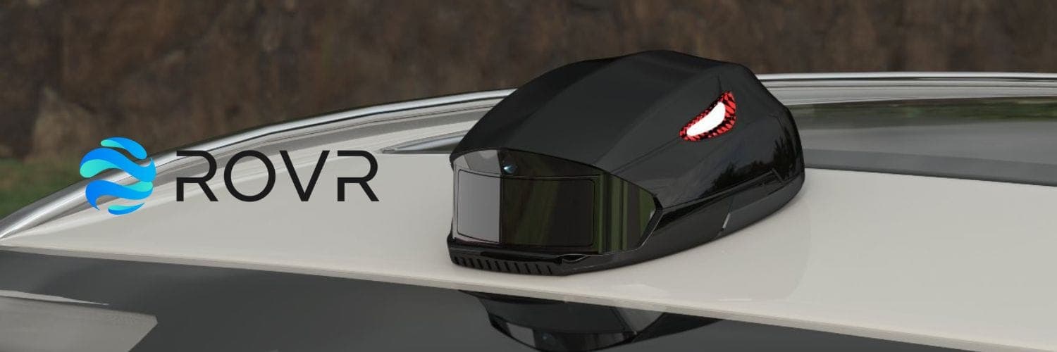
TarantulaX (TX)

A compact $199 device that mounts to a car roof and connects to a smartphone. With corrections from GEODNET’s RTK satellite network, it transforms everyday driving into centimeter-accurate geospatial data. It’s designed for scale — anyone with a car can join.
LightCone (LC)

A $2,499 professional-grade rig with LiDAR, cameras, RTK antennas, and IMUs. It captures dense, highly precise 3D spatial data. Around 200 units are already deployed, including with enterprise clients.
Together, these devices produce HD maps and 3D datasets accurate enough for AV navigation, city planning, and even humanoid robot training!

For contributors, it’s simple: drive your commute. Collect data. And earn.
Already, 1,862 TX devices are live in the field, operated by commuters, fleet managers, DePIN enthusiasts, and mapping engineers!
And to ease the obvious question: privacy matters. Faces and license plates are blurred on-device, then blurred again in the cloud, ensuring compliance with data protection standards worldwide!
ROVR is about more than technology, though. Its community is already shaping the network.
Early TarantulaX users became Discord mods, helping test updates, give feedback, and manage the community itself.
This is infrastructure being built not just for people, but with them.
Proof of Work, anyone? From Paris to Paying Clients
Feeling like all of this is too good to be true?
It’s easy to dismiss Paris as a flashy demo, but Paris isn’t the end of the story. It’s the beginning.
ROVR already has its first paying customer, with a public announcement on the way, plus 5–10 more clients in proof-of-concept stages. That includes Tier 2 automotive suppliers integrating ROVR’s 3D data into production, and international vendors running pilots!

And momentum is accelerating. In October, ROVR will launch a multi-city campaign, scaling coverage across regions to keep up with enterprise demand.
From Paris streets to commercial contracts, the signal is clear: decentralized mapping works, and customers are ready to pay for it.

The lesson is simple: decentralized mapping isn’t just possible, it’s actually commercially viable. And the numbers back it up: contributors have now mapped over 16.7 million kilometers of road worldwide since launch, feeding into datasets accurate enough to power autonomous vehicles and real-time urban planning.
The World Can Be Digitized and Open
Now, zoom out. What happens when this scales?
The possibilities stretch across industries:
- Autonomous vehicles trained on centimeter-accurate maps that refresh daily.
- Robotics labs feeding real-world, structured data into humanoid robots.
- Frontier AI research developing world models grounded in reality, not synthetic shortcuts.
- City planners updating infrastructure in real-time, spotting road changes as they happen.
These aren’t pipe dreams. They’re already showing up in ROVR’s client base: automotive companies, robotics labs, universities, and research institutes!
And here’s the kicker: this dataset won’t stay closed. ROVR plans to open-source the largest 3D dataset in history, bigger and more diverse than Waymo’s Open Dataset.
The difference is, Waymo’s dataset is academic-only. ROVR’s will be usable for both commercial and research applications.
As the team put it: “Our mission is to become the data infrastructure for AI and humanoid robot training.”
Few projects in the world can credibly make that claim.
That’s why it mattered when GEODNET and Borderless Capital co-led ROVR’s $2.6M seed round.

GEODNET provides the RTK corrections that make centimeter accuracy possible, and ROVR turns that accuracy into Paris-scale maps.
Tokenomics & Participation
So where does the community fit in? Everywhere.
ROVR’s incentive system turns driving into data collection:
- 1.6 ROVR/km for TarantulaX
- 16 ROVR/km for LightCone
Rewards halve annually, encouraging both early participation and fresh coverage. Data is scored for quality and novelty, ensuring contributors aren’t just spamming repeats but delivering useful updates.

And the economics go further. Every dataset sold feeds into a deflationary loop:
- 60% → buy + burn $ROVR
- 20% → buy + burn $GEOD
- 20% → operations
The first burn hasn’t happened yet, but with dataset sales underway, it’s imminent. When it starts, every real-world sale will tighten supply and fuel the ecosystem.
This is how you bootstrap a data economy: align contributors, infrastructure, and enterprise buyers in one loop!
From Paris to the World!
ROVR has already shown the world what’s possible.
- A city mapped in weeks.
- A dataset made public.
- Devices in the hands of everyday contributors.
- Enterprises ALREADY paying!
The next step is scaling that proof across continents. With October’s multi-city campaign, a growing list of enterprise clients, and the world’s largest open 3D dataset on the horizon, ROVR isn’t just another DePIN, it’s becoming the geospatial backbone of the AI era.
Paris was proof. The world is the possibility.
Check out more from ROVR Network: